From Toyo Port to Dogo Onsen: By Expressway or by National Routes 196 and 11
From getting off the ferry at Toyo Port, which is due to arrive at 6 a.m. with your car on the overnight ferry from Osaka, to Dogo Onsen. We checked on official pages the route by the Imabari-Komatsu Expressway and the Matsuyama Expressway, the route by National Routes 196 and 11, rest places open early in the morning, and the schedule of suspended sailings and night closures.
Summary
- The sailing from Osaka Nanko is due to arrive at Toyo Port at 06:00, and the guide says on-board rest for cars is until 07:00.
- The Osaka to Toyo sailing is announced as suspended for a periodic inspection from Tuesday, October 20 to Monday, November 2, 2026.
- There are 2 ways from Toyo Port to Matsuyama: the toll expressway, or the free National Routes 196 and 11.
- The official map says about 50 minutes from the Matsuyama direction to Toyo Port. We could not find a driving time from the port to Dogo Onsen.
- Dogo Onsen Honkan is open from 6:00, and Dogo Onsen Parking from 5:30.
This article is based on official sources and maps. A record of the operator actually driving this route will be added after the drive.
A driving video is in preparation. When it is published, it will appear here with chapters numbered the same as the points below.
Map and points
Point locations: © OpenStreetMap contributors (ODbL) ・ License
Toyo Port Ferry Terminal (東予港フェリーターミナル)
StartOrange Ferry's timetable gives 06:00 as the scheduled arrival time at Toyo Port for the sailing from Osaka Nanko.
Location 33.929892, 133.118352 · Source 航路・時刻表|関西航路(東予-大阪)|オレンジフェリー|四国開発フェリー株式会社
National Route 196 near Toyo Port (国道196号(東予港の近く))
Merge / splitWe could not find an official page that gives the route from the port to National Route 196. In the map data, Prefectural Road 148 (Toyo-ko Mitsuya Line) and Prefectural Road 143 (Nyugawa-ko Komatsu Line) pass near the port.
Location 33.927187, 133.096983 · Source OpenStreetMap(way/702052271)
Traffic light intersection where National Route 196 meets National Route 11 (国道196号と国道11号が出会う信号交差点)
Merge / splitIn the map data, this is the traffic light intersection at the end of National Route 196, and from here you drive on National Route 11.
Location 33.897176, 133.108585 · Source OpenStreetMap(node/412335557)
Michi-no-Eki Komatsu Oasis, Ishizuchisan Highway Oasis (道の駅 小松オアシス(石鎚山ハイウェイオアシス))
ParkingThe Ministry of Land, Infrastructure, Transport and Tourism's Michi-no-Eki information says the parking lot is "available 24 hours" (「24時間利用可能」). In the map data, an unnamed road leads to it from the intersection at point 3.
Location 33.883872, 133.107686 · Source 道の駅情報|小松オアシス
National Route 11, Sakurasanri (国道11号 桜三里)
PassThe 5.8 km of National Route 11 from Shikawa in Tanbara-cho, Saijo City, to Kawanouchi in Toon City is a pre-closure traffic regulation section that is closed at 300 mm of continuous rainfall. In the map data, the Sakurasanri Reien-mae bus stop is on this road.
Location 33.806587, 132.972147 · Source 松山河川国道事務所/事務所紹介/出張所紹介/道の管理について
Intersection of National Route 11 and Matsuyama Tobu Ring Road (国道11号と松山東部環状線の交差点)
TurnIn the map data, this is where Prefectural Road 40 (Matsuyama Tobu Ring Road) meets National Route 11. From here you follow the ring road toward Dogo Onsen.
Location 33.808758, 132.814104 · Source OpenStreetMap(node/722015111)
Henro-bashi Kita intersection (遍路橋北 交差点)
Merge / splitA traffic light intersection where Matsuyama Tobu Ring Road meets National Route 317. The map data registers its name as 「遍路橋北」 (Henro-bashi Kita).
Location 33.845583, 132.797134 · Source OpenStreetMap(node/592269628)
Entrance to Prefectural Road 187, Rokkenya-Ishite Line (県道187号 六軒家石手線の入口)
TurnA traffic light intersection on National Route 317. From here, Prefectural Road 187 (Rokkenya-Ishite Line) continues to near Dogo Onsen Honkan.
Location 33.846774, 132.796770 · Source OpenStreetMap(node/592269634)
Shiki Memorial Museum (子規記念博物館)
PassThe Dogo Onsen official site says you can enter Dogo Onsen Parking only by turning right from the south side (the Shiki Memorial Museum side).
Location 33.849701, 132.787045 · Source アクセス | 【公式サイト】道後温泉
Dogo Onsen Parking, Kanmuriyama (道後温泉駐車場(冠山))
ParkingThe parking lot on the south side of Honkan. The Dogo Onsen official site gives its hours as 5:30-23:30.
Location 33.851788, 132.786133 · Source アクセス | 【公式サイト】道後温泉
Dogo Onsen Honkan (道後温泉本館)
ArriveThe top page of the Dogo Onsen official site gives the hours for the ground floor of Kami no Yu as 6:00-23:00 (last entry 22:30).
Location 33.852062, 132.786404 · Source 【公式サイト】道後温泉
The sailing that leaves Osaka Nanko at night is due to arrive at Toyo Port at 6 a.m.
The route that brings cars from Osaka to Toyo Port (東予港) is the “Kansai Route (Toyo-Osaka)” of Shikoku Kaihatsu Ferry (四国開発フェリー), known as Orange Ferry (オレンジフェリー). The timetable page lists one sailing from Toyo Port and one from Osaka Nanko (大阪南港). The entry for Osaka Nanko, which this article covers, is as follows.
| Osaka Nanko to Toyo Port | |
|---|---|
| Boarding opens | From 20:00 |
| Departure | 22:00 |
| Scheduled arrival | 06:00 |
| On-board rest | Until 07:00 |
Source: 航路・時刻表|関西航路(東予-大阪)|オレンジフェリー|四国開発フェリー株式会社
The same page has notes for people who board with a car.
※お車で乗船されるお客様で船内休憩をご希望の場合は、指定のステッカーを車窓に掲示の上ご乗船ください。 (手続きがない場合は翌朝到着後にお車の移動が必要となります。)
Translation: “Note: If you board with a car and want to rest on the ship, please display the designated sticker in the car window when you board. (If the procedure is not done, you will need to move your car after arrival the next morning.)”
ドック期間中は乗船時間が変更になる場合がございますので必ずご確認ください。
Translation: “During the dock period, the boarding time may change, so please be sure to check.”
Source: 航路・時刻表|関西航路(東予-大阪)|オレンジフェリー|四国開発フェリー株式会社
The “Steps for using the ferry” (ご利用の流れ) page has a “Rest on board” column that describes resting on the ship after arrival at Toyo Port.
大阪南港着はAM8:00まで 東予港着はAM7:00まで
Translation: “Arrival at Osaka Nanko is until 8:00 a.m.; arrival at Toyo Port is until 7:00 a.m.”
船内にて休息出来ます。目的地、目的場所に合わせてご自由に出発いただけます。 お車の場合は、船内休息される旨を乗船前に駐車場のスタッフまでお申し付けください。 船内休息ご希望のお車が多い場合、港到着後にお車の移動を御願いする場合がございます。
Translation: “You can rest on the ship. You are free to leave to suit your destination. If you have a car, please tell the parking staff before boarding that you will rest on board. If many cars want to rest on board, we may ask you to move your car after arrival at the port.”
Source: ご利用の流れ|関西航路(東予-大阪)|オレンジフェリー|四国開発フェリー株式会社
This Toyo-Osaka page does not say how people who do not rest on board return to their cars and drive off after the ship berths. The rules for the vehicle deck and the check-in deadlines are collected in the article on boarding a ferry with a car.
The Osaka to Toyo sailing has a notice of suspension from October 20 to November 2, 2026
The sailing that arrives at Toyo Port in the morning is this one sailing from Osaka Nanko. A notice that Orange Ferry issued dated August 20, 2026, describes the suspension for a periodic inspection (dock) as follows.
| Sailing | Suspended dates |
|---|---|
| Osaka to Toyo | Tuesday, October 20 to Monday, November 2, 2026 |
■東予~大阪航路 ドック船:「おれんじ おおさか」
Translation: “Toyo-Osaka route. Ship in dock: ‘Orange Osaka’.”
※東予発→大阪行きは通常運航しています。
Translation: “Note: The Toyo to Osaka sailing runs as usual.”
Source: 関西航路 定期検査(ドック)による一部休航のお知らせ | 重要 | オレンジフェリーからのお知らせ | 四国開発フェリー株式会社
The same notice also says an extra sailing on the Kobe to Niihama route will run during this period.
【神戸23:10発→新居浜06:00着】
Translation: “[Departs Kobe 23:10, arrives Niihama 06:00]”
Source: 関西航路 定期検査(ドック)による一部休航のお知らせ | 重要 | オレンジフェリーからのお知らせ | 四国開発フェリー株式会社
Niihama Higashi Port (新居浜東港) is a different port from Toyo Port. The roads in this article start from Toyo Port, and the roads from Niihama Higashi Port are not covered. As of October 13, 2026, the suspension period is still ahead. For the schedule of sailings after November 2, check the timetable page.
For the driving time from Toyo Port to Matsuyama, we found only a map for the direction toward Toyo Port
We could not find an official page that says how many minutes it takes by private car or rental car from Toyo Port to Dogo Onsen (道後温泉). What we found were a map for the direction toward Toyo Port, and a table from expressway interchanges to Dogo Onsen Honkan.
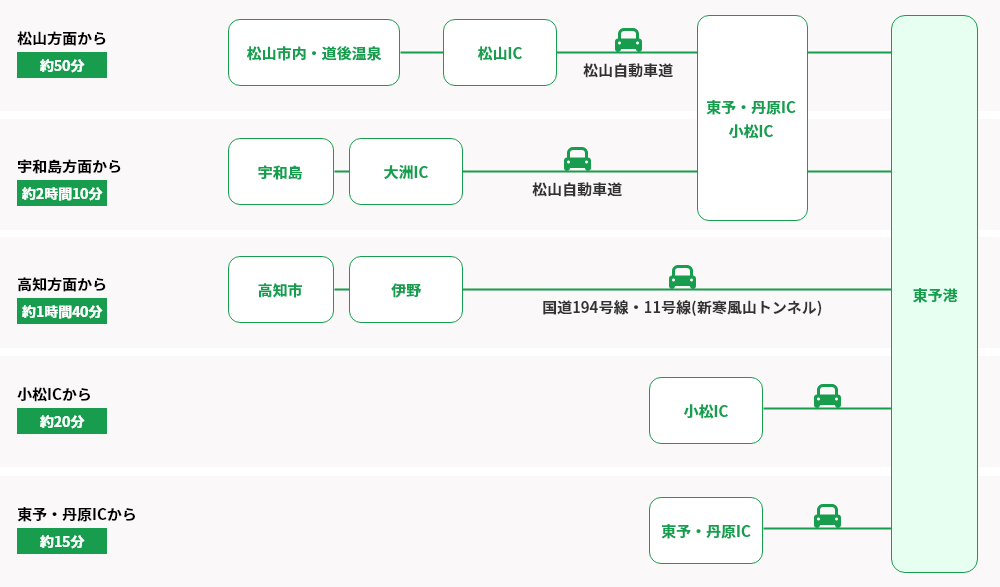
The “Access by car” (車でのアクセス) on Orange Ferry’s Toyo Port page is a single map. It has row headings on the left edge, and lines leading to “Toyo Port” (東予港) on the right edge. The text in the map is as follows.
| Text at the left edge of the map | Travel time in the map |
|---|---|
| From the Matsuyama direction | About 50 minutes |
| From the Uwajima direction | About 2 hours 10 minutes |
| From the Kochi direction | About 1 hour 40 minutes |
| From Komatsu IC | About 20 minutes |
| From Toyo-Tanbara IC | About 15 minutes |
Source: 東予港の車でのアクセス図(画像、オレンジフェリー). The map is on the page 東予港|のりば案内・連絡バス|関西航路(東予-大阪)|オレンジフェリー|四国開発フェリー株式会社
In the row “From the Matsuyama direction”, the map lists from the left Matsuyama city / Dogo Onsen (松山市内・道後温泉), Matsuyama IC (松山IC), Matsuyama Expressway (松山自動車道), Toyo-Tanbara IC (東予・丹原IC), and Komatsu IC (小松IC), with Toyo Port at the right edge. In the row for the Kochi direction, it says National Routes 194 and 11 (Shin-Kanpuzan Tunnel), written as 「国道194号線・11号線(新寒風山トンネル)」. The map is for arriving at the port, and its starting point is the “Matsuyama direction”. It is not a time for the direction from the port to Dogo Onsen.
The time on the side closer to Dogo Onsen is in the table “Come to Matsuyama by car!” (お車で松山へ!) of the Matsuyama Convention & Visitors Bureau.
| From | To | Travel time |
|---|---|---|
| Matsuyama IC | Dogo Onsen Honkan | 25 minutes |
| Kawauchi IC | Dogo Onsen Honkan | 30 minutes |
Under the heading “Getting around the city” (市内の移動手段) on the same page, it says “Note: Travel times may vary depending on traffic conditions and other factors.”
Source: 松山市について・アクセス|公益財団法人 松山観光コンベンション協会 ~いで湯と城と文学のまち~
We do not add these numbers, which have different starting points, to make a time from the port to Dogo Onsen.
We could not find an official page with the route from the port grounds to National Route 196
The Toyo Port page has a guide about searching in a car navigation system.
カーナビで検索の場合は、0898-64-4121 で検索してください。
Translation: “If you search with a car navigation system, please search for 0898-64-4121.”
Source: 東予港|のりば案内・連絡バス|関西航路(東予-大阪)|オレンジフェリー|四国開発フェリー株式会社
This phone number is the same as the number listed as the Toyo reservation center on the company’s “Steps for using the ferry” page.
We could not find an official page that explains in text the route from the port grounds to the public road. What we could confirm in the map data (OpenStreetMap) are the names of the roads that pass near the port.
| Road name | Type in the map data |
|---|---|
| Prefectural Road 148, Toyo-ko Mitsuya Line (県道148号 東予港三津屋線) | A prefectural road that passes near the port |
| Prefectural Road 143, Nyugawa-ko Komatsu Line (県道143号 壬生川港小松線) | A prefectural road that passes near the port |
| National Route 196 | A national route. In the map data, it runs from Matsuyama City to Saijo City |
We will add the position of the exit, and which of these 3 roads is the easiest to follow to National Route 196, after we drive the route.
The expressway route goes through Toyo-Tanbara IC, the Imabari-Komatsu Expressway, and the Matsuyama Expressway, in that order
The route that uses expressways enters the Imabari-Komatsu Expressway at Toyo-Tanbara IC, changes to the Matsuyama Expressway at Iyo-Komatsu JCT, and runs as far as Matsuyama IC or Kawauchi IC. In the Orange Ferry map, too, the row “From the Matsuyama direction” shows “Matsuyama IC”, “Matsuyama Expressway”, and “Toyo-Tanbara IC”.
The interchanges and other places whose positions we checked in the map data are as follows.
| Place | Latitude | Longitude |
|---|---|---|
| Toyo-Tanbara IC (東予丹原IC) | 33.921304 | 133.074439 |
| Iyo-Komatsu JCT (いよ小松JCT) | 33.880985 | 133.085564 |
| Sakurasanri PA, downbound (桜三里PA(下り)) | 33.804228 | 132.942175 |
| Kawauchi IC (川内IC) | 33.793630 | 132.900297 |
| Matsuyama IC (松山IC) | 33.793636 | 132.777405 |
In the map data, both the Imabari-Komatsu Expressway and the Matsuyama Expressway are recorded as toll roads.
For the fare, we read the Matsuyama IC and Toyo-Tanbara IC columns of NEXCO West Japan’s “Simple expressway fare table” (高速道路簡易料金表) for Shikoku, standard-size cars. In the table’s legend, the upper row is the section distance (km) and the lower row is the regular fare; there are separate columns for the 30% late-night discount and the 30% holiday discount.
| Section (standard car) | Section distance | Regular fare | Column for 30% late-night discount and 30% holiday discount |
|---|---|---|---|
| Matsuyama IC to Toyo-Tanbara IC | 37.4 km | 1,170 yen | 820 yen |
Source: 高速道路簡易料金表 四国・普通車(PDF、NEXCO西日本)
This table says “as of March 23, Reiwa 6 (2024)”. It may not be the current fare. Check it with NEXCO West Japan’s fare search before you leave.
For the rest place Sakurasanri PA (downbound), the Drive Plaza page says the parking lot has “Large 7 / Small 16” and the toilets are “Men: large 2, small 5 / Women: 7”. The “previous IC” is “Iyo-Komatsu JCT” at “17.4 km”, and the “next IC” is “Kawauchi” at “4 km”. We found no entry for opening hours.
Source: 桜三里PA(下)・松山自動車道 | ドラぷら(NEXCO東日本)
The Imabari-Komatsu Expressway is closed at night from November 10 to 19
NEXCO West Japan gives the hours of the autumn night closures as follows.
夜間通行止めは、毎夜19時から翌朝6時まで実施します。
Translation: “Night closures are carried out every night from 19:00 to 6:00 the next morning.”
Source: 四国内の高速道路の対面通行区間において秋季夜間通行止めを実施します | NEXCO 西日本 企業情報
The section and dates of the Imabari-Komatsu Expressway are in the table of the same notice.
E76 今治小松道 今治湯ノ浦(いまばりゆのうら)IC~いよ小松(こまつ)IC 上下線 ※いよ小松JCT・ICはご利用できます。
Translation: “E76 Imabari-Komatsu Expressway. Imabari-Yunoura IC to Iyo-Komatsu IC, both directions. Note: Iyo-Komatsu JCT and IC can be used.”
令和8年11月10日(火曜)夜から11月19日(木曜)朝まで【土日除く7夜間】 予備日:令和8年11月19日(木曜)夜から11月21日(土曜)朝まで
Translation: “From the night of Tuesday, November 10, Reiwa 8 (2026), to the morning of Thursday, November 19 [7 nights, excluding Saturdays and Sundays]. Reserve dates: from the night of Thursday, November 19, to the morning of Saturday, November 21, Reiwa 8.”
※土曜日・日曜日・祝日に夜間通行止めは行いませんが、金曜日の夜間通行止めの解除が土曜の早朝となります。
Translation: “Note: There are no night closures on Saturdays, Sundays, or holidays, but the Friday night closure is lifted early on Saturday morning.”
Source: 四国内の高速道路の対面通行区間において秋季夜間通行止めを実施します | NEXCO 西日本 企業情報
Toyo-Tanbara IC is within this “Imabari-Yunoura IC to Iyo-Komatsu IC” section. The closure lasts until 6 a.m. the next morning, and the scheduled arrival at Toyo Port for the sailing from Osaka is 06:00. Orange Ferry’s notice gives the detour for this section as “National Routes 196 and 11 (about 25 minutes)” (国道196号、11号(約25分)).
Source: 令和8年 秋季 四国高速道路 夜間通行止め | 九四航路 | オレンジフェリーからのお知らせ | 四国開発フェリー株式会社
The local-road route goes from National Route 196 to National Route 11, then through Matsuyama Tobu Ring Road and National Route 317 to Dogo Onsen
The route to Dogo Onsen using only local roads goes from National Route 196 onto National Route 11, then moves to Matsuyama Tobu Ring Road. If you enter Prefectural Road 187 from a traffic light intersection on National Route 317, you come out near Dogo Onsen Honkan. We could not find an official page that gives the local-road route from the port to Dogo Onsen, so the table below lists the roads that connect in the map data.
| Order | Road name (map data) | Position |
|---|---|---|
| 1 | National Route 196 | From near the port to the traffic light intersection where it meets National Route 11 (33.897176, 133.108585) |
| 2 | National Route 11 | From that traffic light intersection to the intersection with Matsuyama Tobu Ring Road (33.808758, 132.814104) |
| 3 | Prefectural Road 40, Matsuyama Tobu Ring Road (県道40号 松山東部環状線) | From the intersection with National Route 11 to Henro-bashi Kita intersection on National Route 317 (33.845583, 132.797134) |
| 4 | National Route 317 | From Henro-bashi Kita intersection to the entrance of Prefectural Road 187 (33.846774, 132.79677) |
| 5 | Prefectural Road 187, Rokkenya-Ishite Line (県道187号 六軒家石手線) | From the traffic light intersection on National Route 317 to near Dogo Onsen Honkan. The straight-line distance calculated from positions in the map data is about 1 km |
In the map data, National Route 196 is registered as a route from Matsuyama City, Ehime Prefecture, to Saijo City, Ehime Prefecture, and National Route 11 as a route from Tokushima City, Tokushima Prefecture, to Matsuyama City, Ehime Prefecture. On the page “道の管理について” (About road management) of the Matsuyama River and National Highway Office, the section of National Route 11 managed by the Matsuyama No. 1 National Highway Maintenance Branch is described as from the city border of Saijo City and Toon City to in front of Matsuyama City Hall. In the map data, National Route 11 overlaps other national routes inside Matsuyama City and has one-way sections. The route in this article goes around by the ring road without entering the center of Matsuyama.
In the map data, the end of Prefectural Road 187 is recorded as Ishite 3-chome, Matsuyama City. It is the road that passes near Dogo Onsen Honkan, and it also appears in the Matsuyama Kanko Port article.
For National Route 11 in Komatsucho, the Ministry of Land, Infrastructure, Transport and Tourism page lists the “National Route 11 Komatsu Bypass” (国道11号小松バイパス). The section is from Shinyashiki, Komatsucho, Saijo City, to Yasui, and the length is given as 「7.5km※暫定2車線供用済み2.4km」 (7.5 km; note: 2.4 km in service as temporary 2 lanes). The whole bypass has not opened yet. We could not decide from the map data alone whether the route in this article goes through the bypass.
Sakurasanri is a section that closes in heavy rain
About Sakurasanri on National Route 11, the Matsuyama River and National Highway Office says the following.
松山第一国道維持出張所の管理区間内では、国道33号の山間部及び国道11号の桜三里(事前通行規制マップ参照)で、 連続雨量が基準値を超えた場合や落石、土砂崩れ等の危険が予想される際には、通行止めを行ない利用者の安全確保に努めています。
Translation: “Within the section managed by the Matsuyama No. 1 National Highway Maintenance Branch, on the mountain section of National Route 33 and on Sakurasanri of National Route 11 (see the pre-closure traffic regulation map), we close the road to protect the safety of users when continuous rainfall exceeds the standard value or when there is expected danger of rockfall, landslide, or similar events.”
The row for National Route 11 in the table on the same page is as follows.
| Number | Regulated section | Length | Regulation condition |
|---|---|---|---|
| 1: Route 11 | Shikawa, Tanbara-cho, Saijo City, Ehime Prefecture, to Kawanouchi, Toon City, Ehime Prefecture | 5.8 km | 300 mm of continuous rainfall |
The procedure for lifting the regulation matters for a morning arrival.
雨が止んで2時間後に通行規制区間内をパトロールし、安全が確認され、さらにその後の気象条件等を考慮したうえで通行規制を解除します。ただし、夜間の場合は十分な安全確認が出来ないため、夜明けを待ってからパトロールを行います。
Translation: “Two hours after the rain stops, we patrol the regulated section, and after safety is confirmed and the weather conditions after that are taken into account, we lift the traffic regulation. However, at night we cannot confirm safety sufficiently, so we wait for dawn before patrolling.”
Source: 松山河川国道事務所/事務所紹介/出張所紹介/道の管理について
On a morning after rain at night, you need to check before you leave whether the regulated section has been lifted. Where to check is collected in the article on road information, and the list of rainfall standards is in the article on heavy rain and typhoons.
The rest place you can use on local roads at around 6 a.m. is the parking lot and toilets of Michi-no-Eki Komatsu Oasis
Near the intersection where National Route 196 meets National Route 11, there is Michi-no-Eki “Komatsu Oasis”. The description in the Michi-no-Eki information of the Ministry of Land, Infrastructure, Transport and Tourism is as follows.
道の駅「小松オアシス」は、愛媛県東部、松山自動車道の石鎚SAに隣接し、一般道だけでなく松山自動車道からも利用が可能な「道の駅」です。
Translation: “Michi-no-Eki ‘Komatsu Oasis’ is in the eastern part of Ehime Prefecture, next to Ishizuchi SA on the Matsuyama Expressway. It is a ‘Michi-no-Eki’ that can be used not only from local roads but also from the Matsuyama Expressway.”
In the hours column, 24-hour entries and shop-hours entries are listed together.
モンベルアウトドアオアシス石鎚:午前10時~午後7時 (駐車場・屋外トイレは24時間) おあしす市場:4月~9月 午前9時~午後6時 / 10月~3月 午前9時~午後5時30分
Translation: “Montbell Outdoor Oasis Ishizuchi: 10 a.m. to 7 p.m. (parking lot and outdoor toilets: 24 hours). Oasis Market: April to September, 9 a.m. to 6 p.m. / October to March, 9 a.m. to 5:30 p.m.”
駐車場:普通車101台/大型車1台/身障者用1台(24時間利用可能)
Translation: “Parking: 101 standard cars / 1 large vehicle / 1 for people with disabilities (available 24 hours).”
Source: 道の駅情報|小松オアシス
From October to March, Oasis Market opens at 9 a.m., and the Montbell shop opens at 10 a.m. What the official page says you can use at around 6 a.m. is the parking lot and the outdoor toilets. In the map data, an unnamed road leads toward Ishizuchisan Highway Oasis from the traffic light intersection where National Route 196 meets National Route 11. We will add whether you can actually drive this road after we drive the route.
The rest place if you use the expressway is Sakurasanri PA (downbound), described in the previous section. The hours of the Michi-no-Eki in the prefecture are collected in the list of Michi-no-Eki.
Dogo Onsen: Honkan opens at 6:00, and the parking lot at 5:30
The top page of the Dogo Onsen official site gives the hours of Honkan.
神の湯階下6:00~23:00(札止め22:30)
Translation: “Kami no Yu, ground floor: 6:00 to 23:00 (last entry 22:30).”
Source: 【公式サイト】道後温泉
The hours of the parking lots are on the “Access” page.
In the hours column for each parking lot, Dogo Onsen Parking, Kanmuriyama (道後温泉駐車場(冠山)) is “5:30~23:30” and Dogo Onsen Iwaidani-higashimachi Parking (道後温泉祝谷東町駐車場) is “24時間営業” (open 24 hours).
Source: アクセス | 【公式サイト】道後温泉
The entrance of Dogo Onsen Parking, Kanmuriyama, can be used only by turning right from the south. For the capacity, fees, and the temporary parking lot, including the differences between official pages, see the Matsuyama Kanko Port article and the Matsuyama Airport article.
What comes next for this article
This article is written only from official pages and map data, and we have not driven the route yet. The latitude and longitude of the points and the road names are checked against OpenStreetMap information. The point numbers will match the chapter numbers of the driving video. After we drive the route, we will add the position of the port exit, the road to National Route 196, the layout of the intersection of National Route 11 and Matsuyama Tobu Ring Road, and the time it actually took.
The following could not be confirmed on the official pages.
- The driving time from Toyo Port to Dogo Onsen (one that starts at the port)
- A text description of the route from the port grounds to National Route 196
- An official page that gives the local-road route from the port to Dogo Onsen
- The current expressway fare (the simple fare table is as of March 23, Reiwa 6)
- In which directions you can enter and exit at Toyo-Tanbara IC
- The opening hours of Sakurasanri PA (downbound)
- Construction and regulation plans for National Route 11 (we did not find any in the notices of the Matsuyama River and National Highway Office)
- The detour when the pre-closure traffic regulation on National Route 11 is in effect
- The sailings from Osaka to Toyo after November 2
Parking (3)
| Name | Spaces | Fee | Hours | Notes | Source |
|---|---|---|---|---|---|
| Toyo Port Ferry Terminal Free Multi-story Parking (東予港フェリーターミナルの無料立体駐車場) 愛媛県西条市今在家1500番地2(東予港の所在地) | — | Free | — | Orange Ferry says to use this free multi-story parking lot if you come to see someone off by car or leave your car behind when you board. We could not find the capacity or hours on the official pages. | 東予港|のりば案内・連絡バス|関西航路(東予-大阪)|オレンジフェリー|四国開発フェリー株式会社 |
| Dogo Onsen Parking, Kanmuriyama (道後温泉駐車場(冠山)) 愛媛県松山市道後湯之町4-30 | — | 100 yen per 30 minutes (1 hour free if you bathe at one of the 3 Dogo Onsen public baths) | 5:30-23:30 | The entrance can only be used by turning right from the south side (the Shiki Memorial Museum side). The capacity is not given here, because official pages give different numbers. For details, see the Matsuyama Kanko Port article and the Matsuyama Airport article. | アクセス | 【公式サイト】道後温泉 |
| Dogo Onsen Iwaidani-higashimachi Parking (道後温泉祝谷東町駐車場) 愛媛県松山市祝谷東町437-1 | 43 | 100 yen per 30 minutes (first 1 hour free whether or not you bathe) | Open 24 hours | The Dogo Onsen official site says it is "about 400 m north of the Dogo Onsen Parking entrance". | アクセス | 【公式サイト】道後温泉 |
Sources
- 航路・時刻表|関西航路(東予-大阪)|オレンジフェリー|四国開発フェリー株式会社 (retrieved October 13, 2026)
- ご利用の流れ|関西航路(東予-大阪)|オレンジフェリー|四国開発フェリー株式会社 (retrieved October 13, 2026)
- 東予港|のりば案内・連絡バス|関西航路(東予-大阪)|オレンジフェリー|四国開発フェリー株式会社 (retrieved October 13, 2026)
- 東予港の車でのアクセス図(画像、オレンジフェリー) (retrieved October 13, 2026)
- 関西航路 定期検査(ドック)による一部休航のお知らせ | 重要 | オレンジフェリーからのお知らせ | 四国開発フェリー株式会社 (retrieved October 13, 2026)
- 令和8年 秋季 四国高速道路 夜間通行止め | 九四航路 | オレンジフェリーからのお知らせ | 四国開発フェリー株式会社 (retrieved October 13, 2026)
- 徳島道・徳島南部道・松山道・今治小松道・高知道 維持修繕工事・建設工事のため夜間通行止 | NEXCO 西日本の高速道路・交通情報 渋滞・通行止め情報 (retrieved October 13, 2026)
- 四国内の高速道路の対面通行区間において秋季夜間通行止めを実施します | NEXCO 西日本 企業情報 (retrieved October 13, 2026)
- 高速道路簡易料金表 | NEXCO 西日本の高速道路・交通情報 渋滞・通行止め情報 (retrieved October 13, 2026)
- 高速道路簡易料金表 四国・普通車(PDF、NEXCO西日本) (retrieved October 13, 2026)
- 桜三里PA(下)・松山自動車道 | ドラぷら(NEXCO東日本) (retrieved October 13, 2026)
- 道の駅情報|小松オアシス (retrieved October 13, 2026)
- 松山河川国道事務所/事務所紹介/出張所紹介/道の管理について (retrieved October 13, 2026)
- 松山河川国道事務所/道路改築事業/国道11号小松バイパス (retrieved October 13, 2026)
- 松山市について・アクセス|公益財団法人 松山観光コンベンション協会 ~いで湯と城と文学のまち~ (retrieved October 13, 2026)
- アクセス | 【公式サイト】道後温泉 (retrieved October 13, 2026)
- 【公式サイト】道後温泉 (retrieved October 13, 2026)
- OpenStreetMap(地点の位置。© OpenStreetMap contributors、ODbL) (retrieved October 13, 2026)
How we cite sources and use map data is explained in Sources and map data. Most sources are in Japanese.
Read before you drive
- Driving a rental car in Ehime as a visitor from abroad: International Driving Permits, foreign licenses with a Japanese translation, and how long you can drive
Three kinds of license are valid for driving in Japan. We checked the official pages for the International Driving Permit format, the six countries and regions whose licenses work with a translation, how long you can drive, the seven rental companies at Matsuyama Airport, and the Ehime Prefectural Police license conversion rules. - Japanese Road Rules for First-Time Drivers from Abroad: Driving on the Left, Red Lights, Stop Signs, Railroad Crossings, Drinking, Mobile Phones, Speed
Driving on the left, red lights and arrows, the "Tomare" stop sign, railroad crossings, drunk driving, mobile phones while driving, seat belts and child seats, and speed limits on ordinary roads, checked against the original text of the Road Traffic Act, the National Police Agency's Rules of the Road, and the NPA's English materials. - What to do and who to contact if you have an accident, a breakdown, or a road problem in Ehime: 110, 119, #9910, JAF, and your rental car company
Who to contact if you have an accident or breakdown, or find a hole or fallen object on the road, while driving in Ehime. Checked against official sources: Article 72 of the Road Traffic Act, foreign-language service on 110 and 119, the order of steps on an expressway, the Road Emergency Dial #9910, JAF, and the rental terms of the seven companies at Matsuyama Airport.
Related articles
- Taking a car on a ferry from an Ehime port: check-in deadlines and rules for the vehicle deck
- From Matsuyama Kanko Port to Dogo Onsen: Prefectural Road 19 and Rokkenya-Ishite Line
- From Matsuyama Airport to Dogo Onsen: Roads and Parking
- 29 Roadside Stations (Michi-no-Eki) in Ehime: Locations, Parking Spaces and Opening Hours
- Roads in Ehime That Close in Heavy Rain and Typhoons: Advance Closure Sections and Rain and Wind Rules on Expressways
- Where to check road information in Ehime before you leave